Categories
Climate malaria OMaWa

Using climate models in malaria models

Weather is important for transmission of malaria. The simplest way to measure the current weather is to walk outside and feel whether it is cold or hot, and see if it is sunny, cloudy, or rainy. Weather and climate models always start with a measurement of the current weather. Rather than relying on the perceived conditions, the weather models need accurate observations of the current weather. Such observations can be derived from satellites measuring the temperature, pressure, winds, and vapour content of the atmosphere. In addition, weather balloons can be used to correct the satellite derived observations. Once the current weather has been measured, these observations can be used as initial conditions in climate and weather models, and weather can be foretasted up to ten days ahead. With additional information about the temperature, density and salinity of the ocean, weather can be projected a season ahead. If you add volcanoes, variability of the sun, and greenhouse gasses, it is possible to estimate historical and future weather and climate.


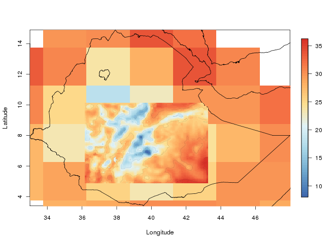
Independent on which time period is of interest, these forecasts, or projections, have to be cover the entire Earth, and the forecasts involves solving millions of equations which demands computational resources. To keep the cost down, the global models are often run with a coarse resolution, dividing the Earth into squares of 250 km x 250 km. In regions where the land is flat for several thousand kilometres, and there is no ocean nearby, these coarse resolutions may be good enough to simulate the weather. Once a mountain, coastline, different land use, or soil types are present, the coarse global models represents the weather poorly. To aid this problem, one can use regional climate models (RCMs).


Regional climate models work by increasing the resolution of the global models in a smaller area, a domain, of interest. Such domain might cover southern Africa, Ethiopia, or western Africa, and resolve the terrain down to one by on km. The global climate model determines the large scale winds, temperatures, pressure, and humidity entering the smaller domain. The regional climate model can then resolve the local impact on weather from land use, orography, soil types etc., giving weather and climate information at much finer resolutions that what is feasible using a global model.

Categories
Climate malaria

Fifteen years of erroneous malaria maps?

It is well known that the transmission of malaria is dependent on temperature, and of particular importance is how temperature controls the longevity of mosquitoes of the Anopheles genus. The temperature driven survival of these mosquitoes, is one of the main causes of the current global distribution of malaria.

The relationship between temperature and malaria transmission has made it possible to construct climate based malaria maps of the theoretical distribution of malaria, dividing severely affected areas, from areas with occasional epidemics. The same methodologies have also been used to project the future impact of climate change on malaria.

In 2013 two scientific papers were published describing how many of these models have been wrong headed. One by Mordecai and colleges, and one by our research group at Centre for International Health and Bjerknes Centre for Climate Research.Both papers claim malaria is transmitted most efficiently around 25 degrees Celsius, 6 °C lower than previous models. Roughly this means places with temperatures below or over 25 °C theoretically will have a lower potential for efficient spread of malaria compared to areas where temperatures are around 25 °C.

To describe the relationship between temperature and mosquito mortality, researchers use theoretical models. One model has been particular popular among scientists, and has been used in for example MARA/ARMA model used by the World Health Organization, to model the global constraints of malaria , and to project the consequences of global warming on malaria here, and here. In our paper we show that this model is not supported by observations, and there are reasons to believe that either the results shown in the mentioned papers are correct for the wrong reasons, or that the results themselves are wrong.

Researchers should now rethink how climate has influenced malaria in the past, present and future.


Categories
Climate OMaWa Uncategorized

Malaria and Temperature

How malaria models relate temperature to malaria transmission


Background

It is well known that temperature has a major influence on the transmission of malaria parasites to their hosts. However, mathematical models do not always agree about the way in which temperature affects malaria transmission.

Methods

In this study, we compared six temperature dependent mortality models for the malaria vector Anopheles gambiae sensu stricto. The evaluation is based on a comparison between the models, and observations from semi-field and laboratory settings.

Results

Our results show how different mortality calculations can influence the predicted dynamics of malaria transmission.

Conclusions

With global warming a reality, the projected changes in malaria transmission will depend on which mortality model is used to make such predictions.


Parasites & Vectors 2013, 6:20

Categories
Climate

Starting to downscale climate data

This autumn part of the EMaPS team are gathered at the Geophysical Institute/University of Bergen to, among other things, focus on down-scaling of climate data. We are now starting to dynamically downscale climate data for a longer period. Since this is computationally heavy we will be using the Cray XT4 system at Parallab. Up till now we have been climbing the steep learning curve, but once we got there the results are coming. The image is showing down-scaled temperature at 2 meters, and is from one of the test runs. The larger cells show the input data.

Testing down-scaling Ethiopia